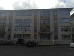
Atlas Street, 16

Atlas Street, 16, Yildirim Neighborhood, Bayrampasa, Istanbul
Coordinates:
41.061994, 28.890251
clipboard
Save
Overview
Businesses inside

Search nearby

Restaurants
Pharmacies
Groceries
ATMs
Housewares
Hotels
Shopping malls
Cafes
Museums
Gas stations
Add an item
Edit information

Directions

Kocatepe
1.75 km
2
KocatepeKaradeniz MahallesiCoach Station
Özgecan Sokak
217 m
3
Özgecan SokakPark AdaPark Ada 1. KapıMeltem Sokak
Show parking info

Businesses in the building

  • Bayrampasa Mehmet Akif Inan Secondary School
    Photos
    Bayrampasa Mehmet Akif Inan Secondary School (Istanbul, Bayrampasa, Yildirim Neighborhood, Atlas Street, 14), school
    5
    Bayrampasa Mehmet Akif Inan Secondary School
    Closed until tomorrow
    School
    Istanbul, Bayrampasa, Yildirim Neighborhood, Atlas Street, 14
  • Bayrampasa Primary School
    Photos
    Bayrampasa Primary School (İstanbul, Bayrampaşa, Yıldırım Mah., Atlas Sok., 16), primary school
    2
    Bayrampasa Primary School
    Rating 4.3
    9 ratings
    9 ratings
    Closed until tomorrow
    Primary school
    İstanbul, Bayrampaşa, Yıldırım Mah., Atlas Sok., 16
  • Bayrampasa Closed Temporary Shelter Area
    Bayrampasa Closed Temporary Shelter Area
    Business hours unknown
    Emergency assembly area
    İstanbul, Bayrampaşa, Yıldırım Mah., Atlas Sok., 16
  • Maps • Istanbul • Bayrampasa
    Report an error
    Services
    Personal
    For business
    Yandex Maps: find where to eat, what to see, and how to have fun
    © 2001–2025 Yandex LLC
    Help
    About
    User agreement