Kizlar Sivrisi Mountain 3070 meters

Address
Contacts
Phone number not specified
Business hours
24 hours
Directions
Similar places nearby
7 reviews
July 21, 2023
Very beautiful peak
7
October 31, 2024
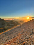
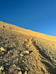
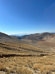
An excellent peak for a good hike, there are several trails for climbing, the one that is shorter in the forehead, but quite steep, there is a more gentle one on the reverse side, but longer. The ascent takes 3-5 hours on average, depending on the preparation. It's windy and cool at the top. There are flat places to put up tents. The places are almost deserted , they do not carry tourists, which makes it even more interesting .
The easiest way to get from the town of Elmali, or you can get more picturesquely from Antalya Saklikent, but it will take longer and he will build a road from there if you choose a hiking route in maps mi, but the road is normal.
See original · Русский
3
October 31, 2024
I carried out a one-day hike on 19.10.2024 with a group of four people. The ascent was carried out from a height of 1720m - it is possible to drive to this height in an all-wheel drive car. The ascent took 4.5 hours, there is no trail in many places, climbing skills and the basics of topographic orientation are necessary for the ascent. The level of difficulty can be assessed as difficult, given the steepness of the ascent in many places and the lack of acclimatization (nevertheless, it must be taken into account that the ascent is likely to be carried out from sea level and will reach more than 3 km).
At this time of the year, there was no snow, the temperature in the evening and at night is slightly below zero. At the top of the mountain there is a Turkish flag and a time capsule - a metal box containing a diary and pens - where climbers who were able to climb the mountain can leave a message in text format. The views are cosmic. Have a good ascent to all!
See original · Русский


5